
 A SCHOLARLY BOOK REPOSITORY
11 start with T start with T
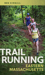
Eastern Massachusetts offers incredible trail-running opportunities, ranging from popular long-distance routes like the Bay Circuit Trail to lesser-known loops that run through the mountains and forests of the Quabbin watershed and Merrimack Valley region, and trails that pass alongside the shores of Cape Cod. All over the Bay State, there are trails suitable for runners of all levels waiting to be discovered and explored.
Avid trail runner Ben Kimball offers a selection of fifty-one of eastern Massachusetts’s most spectacular trail sites, including detailed trail descriptions, topographic maps, directions, parking information, safety tips, and much more. Both experienced and novice trail runners will find Trail Running Eastern Massachusetts to be an invaluable resource for exploring nature and getting a good workout, in the Boston area and beyond.
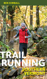
The wild and rural landscape of southern Vermont offers a true bounty of great trail-running opportunities, from out-and-back (or pointtopoint) runs on popular long-distance routes, such as segments of the Long Trail or Appalachian Trail, to quiet, little-known loops hidden away in the woods. This helpful guide is just the resource needed for trip planning or for a spontaneous run in a beautiful place.
Local expert trail runner Ben Kimball offers a range of suggested route options, sometimes even several at the same site, for runners of all skill levels. He also provides important practical information, such as the full distance of the suggested route; a difficulty rating; the trail style and type; the total ascent; and directions, along with a detailed description of the trail itself. There are also scannable codes for downloading trail maps to your smartphone. The trails included vary in difficulty and terrain type, and range from low elevations in the Connecticut River Valley to as high as 4,000 feet at Killington Peak in the Green Mountains. This indispensable book is the perfect companion for adventurous runners and hikers interested in exploring southern Vermont.
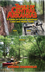
Trails of Central Arkansas delivers:
* Sixty trails in 36 parks or locations from Benton and Bryant to Cabot, from Wrightsville to Conway
* Color maps of every trail
* GPS coordinates for every trailhead
* Color-coded distinctions between paved and unpaved trails
* Level of difficulty ratings
* Scenery Scores
* Top-ten lists: Most Scenic, Trails for Kids, and Trails for Solitude
A Travel Guide to Basque America—the first-ever guide to America’s Basque-American communities, their history, culture, and festivals—has been a best-seller since it first appeared in 1998. This new edition lists dozens of new restaurants, Basque cultural clubs and cultural events, and hundreds of Basque-related Internet sites that have appeared since 1998. It also includes new information about recent events in the Basque Country, their impact on Basque-Americans, and new cultural and community efforts to preserve Basque culture in America. This is the essential guide for Basque-Americans seeking links to their ancient culture and its homeland and their counterparts in the U.S., as well as for any traveler interested in exploring one of this country’s most vibrant and fascinating ethnic minorities.
Driving across I-70 in southern Utah one can’t help but wonder about the magnificent upturned rocks of the San Rafael Reef. With A Travelers Guide to the Geology of the Colorado Plateau in hand, you’ll soon discover that you were driving through Page and Navajo Sandstone formations, sharply folded into a monocline along one of the "Basin and Range" fault lines. Nearing Flagstaff, Arizona, on Highway 89, you will learn that Mt. Humphry of the San Francisco Peaks, a Navajo Sacred Mountain, was once an active volcano. Keep reading and you’ll find many things worth a slight detour.
A Traveler's Guide to the Geology of the Colorado Plateau will enrich and enliven all of your trips through the varied landscapes of the Colorado Plateau as you learn about the geological forces that have shaped its natural features. The mile-by-mile road logs will take you from Vernal, Utah, in the north to the southernmost reaches of the Plateau in Sedona, Arizona; from the red rocks of Cedar Breaks National Monument near Cedar City, Utah, to the edges of the soaring peaks of the San Juan Mountains near Durango, Colorado. The most comprehensive geological guide to the Colorado Plateau
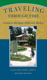
Since 1955 the state of Michigan has erected historical markers throughout the state. In this revised edition of Traveling Through Time, Laura Rose Ashlee collects the histories that appear on these markers together into one handy guidebook---a great desk reference for researchers and armchair historians alike.
Some of the book's special features include:
o Location and full text of each marker
o Arranged alphabetically within county chapters
o More than 85 historic and color photographs
o Special section on Michigan historical markers placed outside Michigan
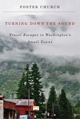
As in his previous book, Discovering Main Street: Travel Adventures in Small Towns of the Northwest, Church employs the finesse of his Pulitzer-Prize-winning journalism. He also shares his passion for encouraging tourists down less traveled paths—paths that curve beside valleys and wheat fields, travel along orchards and straits, and abut mountains and rivers.
Once inside these small towns, local flavors abound. Church reveals how each community’s unique character informs its hospitality and culture: In Morton, the abandoned Roxy movie theater was re-opened to host lectures and live performances. In the town of Palouse, a once-lonesome farming community in the Washington wheat country is now home to antiques shops and art galleries, and in Pomeroy, a pioneering legacy is celebrated in a lively annual festival.
With maps, photographs, and recommendations for more than thirty-five towns in all corners of the state, Turning Down the Sound vastly expands the resources available for readers and travelers keen on encountering what Church calls American tourism’s last frontier: its small towns.
READERS
Browse our collection.
PUBLISHERS
See BiblioVault's publisher services.
STUDENT SERVICES
Files for college accessibility offices.
RECENTLY PUBLISHED


UChicago Accessibility Resources
home | accessibility | search | about | contact us
BiblioVault ® 2001 - 2024
The University of Chicago Press