front cover of The Gough Map
The Gough Map
The Earliest Road Map of Great Britain
Nick Millea
Bodleian Library Publishing, 2005
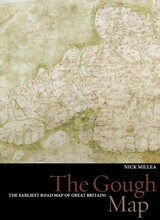
For centuries the Gough Map has amazed observers with its remarkable detail and baffled historians with its hidden secrets: who made it and why was it made? This gorgeously illustrated volume offers possible answers to these questions with a detailed examination of the map that employs the latest in technology, cartographic theories, and historical research.

Recent digitization of the Gough Map has made it more legible than at any other time since its arrival at the Bodleian Library in 1809. This work utilizes new georectification technology to project a modern map of Britain over the Gough Map, revealing the incredible accuracy of the 700-year-old manuscript. In stunningly detailed reproduction, The Gough Map charts a vast array of cities, routes, and landmarks, including the principal medieval settlements of Bristol, Oxford and Norwich; the Severn, Thames, and Humber rivers; the loop of the Wear at Durham; and routes between towns with distances marked in Roman numerals.

The volume also features a color fold-out print of the Gough map, as well as numerous close-up images of each area. The Gough Map offers an unparalleled opportunity to examine this fascinating example of medieval mapmaking.
[more]

front cover of Town
Town
Prints & Drawings of Britain before 1800
Bernard Nurse
Bodleian Library Publishing, 2020
Many provincial towns in Britain grew dramatically in size and importance in the eighteenth century. Ports such as Glasgow and Liverpool greatly expanded, while industrial centers such as Birmingham and Manchester flourished. Market towns outside London developed as commercial centers or as specialty destinations: visitors could find spa treatments in Bath, horse racing in Newmarket, and naval services in Portsmouth. Containing more than one hundred images of country towns in England, Wales, and Scotland, this book draws on the extensive Gough collection in the Bodleian Library. Contemporary prints and drawings provide a powerful visual record of the development of the town in this period, and finely drawn prospects and maps—made with greater accuracy than ever before—reveal their early development. This book also includes perceptive observations from the journals and letters of collector Richard Gough (1735–1809), who traveled throughout the country on the cusp of the industrial age.
[more]


Send via email Share on Facebook Share on Twitter