
 A SCHOLARLY BOOK REPOSITORY
6 start with R start with R

From 1950 to 1990, the Soviet Army conducted a global topographic mapping program, creating large-scale maps for much of the world that included a diversity of detail that would have supported a full range of military planning. For big cities like New York, DC, and London to towns like Pontiac, MI and Galveston, TX, the Soviets gathered enough information to create street-level maps. What they chose to include on these maps can seem obvious like locations of factories and ports, or more surprising, such as building heights, road widths, and bridge capacities. Some of the detail suggests early satellite technology, while other specifics, like detailed depictions of depths and channels around rivers and harbors, could only have been gained by actual Soviet feet on the ground. The Red Atlas includes over 350 extracts from these incredible Cold War maps, exploring their provenance and cartographic techniques as well as what they can tell us about their makers and the Soviet initiatives that were going on all around us.
A fantastic historical document of an era that sometimes seems less distant, The Red Atlas offers an uncanny view of the world through the eyes of Soviet strategists and spies.
You are here, a map declares, but of course you are not, any more than you truly occupy the vantage point into which a landscape painting puts you. How maps and paintings figure and reconfigure space—as well as our place in it—is the subject of Edward S. Casey’s ambitious study, an exploration of how we portray the world and its many places.
Casey’s discussion ranges widely from Northern Sung landscape painting to nineteenth-century American and British landscape painting and photography, from prehistoric petroglyphs and medieval portolan charts to seventeenth-century Dutch cartography and land survey maps of the American frontier. From these culturally and historically diverse forays a theory of representation emerges. Casey proposes that the representation of place in visual works be judged in terms not of resemblance, but of reconnecting with an earth and world that are not the mere content of mind or language—a reconnection that calls for the embodiment and implacement of the human subject.
Representing Place is the third volume in Casey’s influential epic project of reinterpreting evolving conceptions of space in world thought. He combines history with philosophy, and cartography with art, to create a new understanding of how representation requires and thrives on space, ultimately renewing our appreciation of the power of place as it is set forth in paintings and maps.
From the first Slavic migrations to the Romanovs’ rise to the Putin era, Russia has endured for centuries as a nation whose sheer size and diversity have challenged its rulers and shaped its identity. Restless Empire illuminates the epic sweep of Russian history in a beautifully illustrated full-color atlas depicting the essential cultural, political, economic, and military developments of Russia’s past.
Like the double-headed eagle that is its state emblem, Russia has always looked abroad to both the East and West, searching for secure trade routes, trustworthy allies, and defensible frontiers. Expansion beyond Muscovy’s forested confines began in the fifteenth century, when Ivan III rejected Mongol rule and moved into the Russian steppe. The waterways linking the Baltic to the Black and Caspian seas were crucial to Russia’s development from the Middle Ages onward. The age-old quest to acquire warm-water ports culminated in the construction of St. Petersburg in the eighteenth century, when imperial Russia began to rival Europe’s Great Powers.
From Ivan the Terrible to Catherine the Great, Lenin and Stalin to Yeltsin and Putin, Russia’s rulers have carved their nation’s destiny into world history, sometimes bending Russia toward despotism or democracy, internationalism or brusque independence. Russia’s titanic conflicts—against the Tatars and Turks, Napoleon, Nazi Germany, and the United States—and its political upheavals from the Time of Troubles to the Soviet Union’s downfall, as well as ongoing strife in Chechnya and Crimea, are presented chronologically in accessible text accompanied by detailed maps and illustrations.
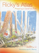
In this sequel to Ellie’s Log: Exploring the Forest Where the Great Tree Fell, Ricky Zamora brings his love of map-making and his boundless curiosity to the arid landscapes east of the Cascades Mountains. He arrives during a wild thunderstorm, and watches his family and their neighbors scramble to deal with a wildfire sparked by lightning. Joined by his friend Ellie, he sees how plants, animals, and people adjust to life with wildfires.
While hiking across a natural prairie, climbing up a fire tower, and studying historical photos and maps, Ricky and Ellie learn about the role of fire in shaping the landscape of the semi-arid plateau east of the mountains. They experience the scary days of wildfire in progress, explore a gritty site after a wildfire, and discover how some plants and animals depend on fire to survive.
Color pen-and-ink drawings accompany the text and vividly illustrate plants, animals, and events encountered in this exciting summer adventure. With his friend Ellie, Ricky creates a brightly colored diary of the fire, with maps, timelines, and sketches of what they see in this fire-prone land. Ricky’s notebook about his summer visit to his uncle’s ranch becomes an atlas of fire ecology, weather patterns, and life in the rain shadow.
Upper elementary kids will enjoy the mixture of amazing adventures with actual historical, physical, and ecological data about the region. Woven into the story are the small pleasures of ranch life, intriguing histories of Native Americans and early settlers, and almost unbelievable views of ancient fossils. Ricky and Ellie’s explorations, accompanied by their hand-written notes, introduce readers to a very special landscape and history east of the mountains.
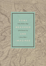
In Rome Measured and Imagined, Jessica Maier explores the history of this genre—which merged the accuracy of scientific endeavor with the imaginative aspects of art—during the rise of Renaissance print culture. Through an exploration of works dating from the fifteenth to the eighteenth centuries, her book interweaves the story of the city portrait with that of Rome itself.
Highly interdisciplinary and beautifully illustrated with nearly one hundred city portraits, Rome Measured and Imagined advances the scholarship on Renaissance Rome and print culture in fascinating ways.
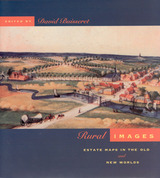
Generously illustrated with reproductions of rare manuscripts, including 8 color plates, these accounts reveal how estate maps performed vital economic and cultural functions for property owners until the end of the nineteenth century. From plans of plantations in Jamaica and South Carolina to a map of Queens College, Cambridge, handsome examples show that estate maps formed an important part of the historical record of property ownership for both individuals and corporations, and helped owners manage their land and appraise its value. Exhibited in public places for pleasure and as symbols of wealth, they often displayed elaborate cartouches and elegant coats-of-arms.
READERS
Browse our collection.
PUBLISHERS
See BiblioVault's publisher services.
STUDENT SERVICES
Files for college accessibility offices.
RECENTLY PUBLISHED


UChicago Accessibility Resources
home | accessibility | search | about | contact us
BiblioVault ® 2001 - 2024
The University of Chicago Press